---
title: Capacitor Geocoder Plugin for Android, iOS & Web
description: Capacitor plugin for handling geocoding and reverse geocoding with cross-platform support and high performance.
tags:
- Insiders
- Android
- iOS
- Web
search:
boost: 2
faq: true
github_repo: capawesome-team/capacitor-plugins
---
# Capacitor Geocoder Plugin
Capacitor plugin for handling geocoding and reverse geocoding.

## Features
The Capacitor Geocoder plugin is one of the most complete geocoding solutions for Capacitor apps. Here are some of the key features:
- 🖥️ **Cross-platform**: Supports Android, iOS and Web.
- 📍 **Geocoding**: Convert addresses into geographic coordinates.
- 🗺️ **Reverse Geocoding**: Convert geographic coordinates into human-readable addresses.
- 🌐 **Multiple Providers**: Support for Google Maps and OpenStreetMap on Web.
- 🌍 **Localization**: Customize the locale for geocoding requests.
- 🔢 **Configurable Results**: Limit the number of addresses returned in reverse geocoding operations.
- 🛠️ **Native APIs**: Uses platform-native geocoding services on Android and iOS for reliable and accurate results.
- 🤝 **Compatibility**: Works alongside the [Compass](https://capawesome.io/docs/sdks/capacitor/compass/) and [Maps Launcher](https://capawesome.io/docs/sdks/capacitor/maps-launcher/) plugins.
- 📦 **CocoaPods & SPM**: Supports CocoaPods and Swift Package Manager for iOS.
- 🔁 **Up-to-date**: Always supports the latest Capacitor version.
- ⭐️ **Support**: Priority support from the Capawesome Team.
- ✨ **Handcrafted**: Built from the ground up with care and expertise, not forked or AI-generated.
Missing a feature? Just [open an issue](https://github.com/capawesome-team/capacitor-plugins/issues) and we'll take a look!
## Use Cases
The Geocoder plugin is typically used whenever an app needs to translate between addresses and coordinates, for example:
- **Address search**: Convert a user-entered address into geographic coordinates to display the location on a map.
- **Location labeling**: Show a human-readable address for given coordinates, for example the user's current position.
- **Address forms**: Prefill address fields such as postal code, country, or administrative area based on coordinates.
- **Localized results**: Return addresses in the user's preferred language using the `locale` option.
## Compatibility
| Plugin Version | Capacitor Version | Status |
| -------------- | ----------------- | -------------- |
| 8.x.x | >=8.x.x | Active support |
| 0.1.x | 7.x.x | Deprecated |
## Demo
| Android | iOS | Web |
| -------------------------------------------------------------------------------------------------------------------- | ------------------------------------------------------------------------------------------------------------ | ------------------------------------------------------------------------------------------------------------ |
| 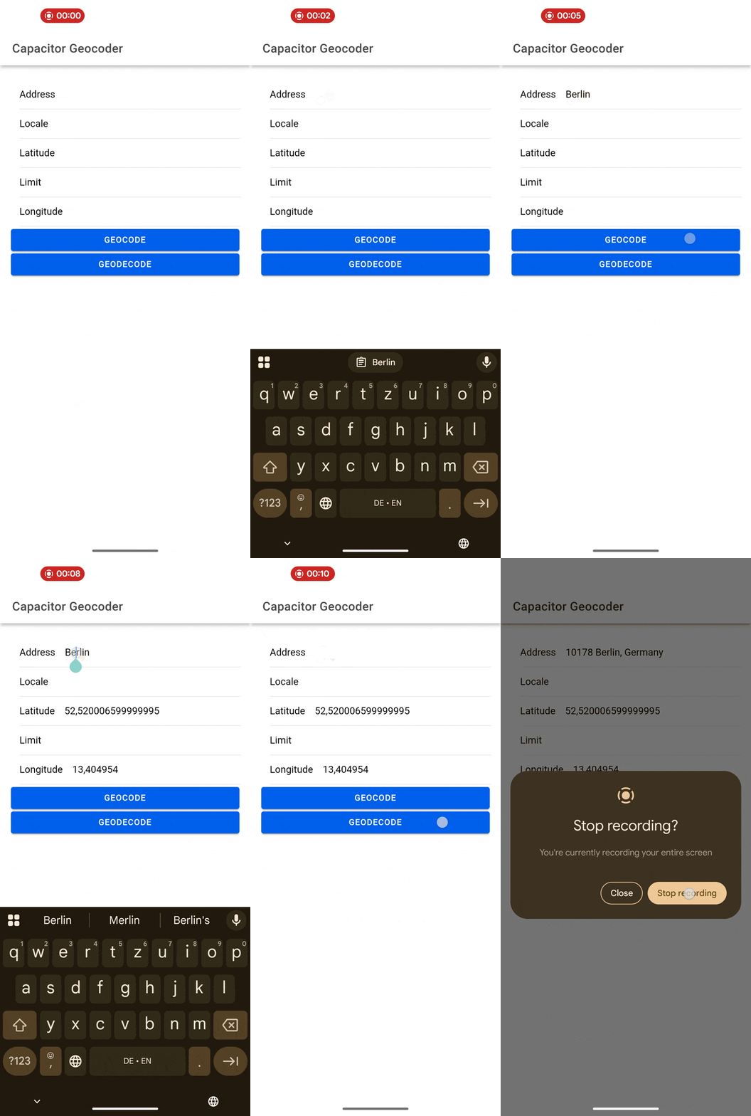 |
| 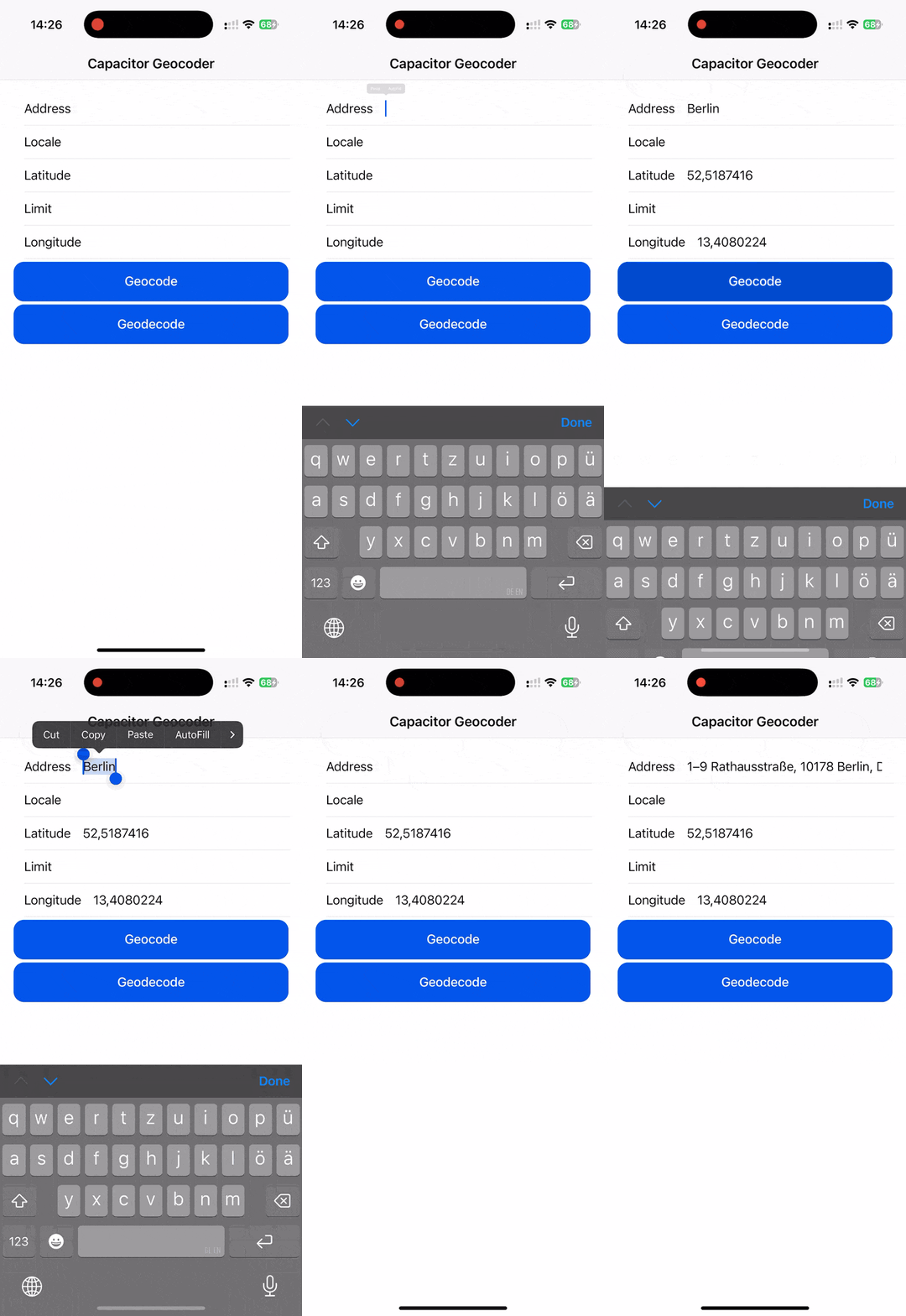 |
| 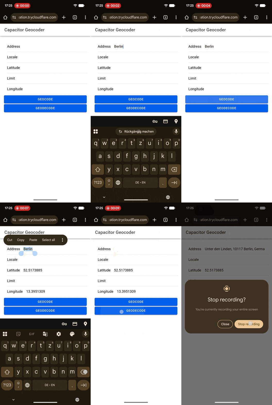 |
## Installation
This plugin is only available to [Capawesome Insiders](https://capawesome.io/insiders/).
First, make sure you have the Capawesome npm registry set up.
You can do this by running the following commands:
```
npm config set @capawesome-team:registry https://npm.registry.capawesome.io
npm config set //npm.registry.capawesome.io/:_authToken
```
**Attention**: Replace `` with the license key you received from Polar. If you don't have a license key yet, you can get one by becoming a [Capawesome Insider](https://capawesome.io/insiders/).
Next, you can use our **AI-Assisted Setup** to install the plugin.
Add the [Capawesome Skills](https://github.com/capawesome-team/skills) to your AI tool using the following command:
```bash
npx skills add capawesome-team/skills --skill capacitor-plugins
```
Then use the following prompt:
```
Use the `capacitor-plugins` skill from `capawesome-team/skills` to install the `@capawesome-team/capacitor-geocoder` plugin in my project.
```
If you prefer **Manual Setup**, install the plugin by running the following commands and follow the platform-specific instructions below:
```bash
npm install @capawesome-team/capacitor-geocoder universal-geocoder
npx cap sync
```
## Usage
The following examples show how to convert an address into coordinates and how to convert coordinates back into an address.
### Convert an address into coordinates
Use the `geocode(...)` method to translate a human-readable address into geographic coordinates, for example to display the location on a map:
```typescript
import { Geocoder } from '@capawesome-team/capacitor-geocoder';
const geocode = async () => {
const result = await Geocoder.geocode({
address: '1600 Amphitheatre Parkway, Mountain View, CA',
});
console.log('Geocode result:', result);
};
```
### Convert coordinates into an address
Use the `geodecode(...)` method to translate geographic coordinates into one or more human-readable addresses. The number of returned addresses can be limited with the `limit` option:
```typescript
import { Geocoder } from '@capawesome-team/capacitor-geocoder';
const geodecode = async () => {
const result = await Geocoder.geodecode({
latitude: 37.422,
longitude: -122.084,
});
console.log('Geodecode result:', result);
};
```
## API
* [`geocode(...)`](#geocode)
* [`geodecode(...)`](#geodecode)
* [Interfaces](#interfaces)
### geocode(...)
```typescript
geocode(options: GeocodeOptions) => Promise
```
Translate an address into geographic coordinates.
Only available on Android and iOS.
| Param | Type |
| ------------- | --------------------------------------------------------- |
| **`options`** |
|
## Installation
This plugin is only available to [Capawesome Insiders](https://capawesome.io/insiders/).
First, make sure you have the Capawesome npm registry set up.
You can do this by running the following commands:
```
npm config set @capawesome-team:registry https://npm.registry.capawesome.io
npm config set //npm.registry.capawesome.io/:_authToken
```
**Attention**: Replace `` with the license key you received from Polar. If you don't have a license key yet, you can get one by becoming a [Capawesome Insider](https://capawesome.io/insiders/).
Next, you can use our **AI-Assisted Setup** to install the plugin.
Add the [Capawesome Skills](https://github.com/capawesome-team/skills) to your AI tool using the following command:
```bash
npx skills add capawesome-team/skills --skill capacitor-plugins
```
Then use the following prompt:
```
Use the `capacitor-plugins` skill from `capawesome-team/skills` to install the `@capawesome-team/capacitor-geocoder` plugin in my project.
```
If you prefer **Manual Setup**, install the plugin by running the following commands and follow the platform-specific instructions below:
```bash
npm install @capawesome-team/capacitor-geocoder universal-geocoder
npx cap sync
```
## Usage
The following examples show how to convert an address into coordinates and how to convert coordinates back into an address.
### Convert an address into coordinates
Use the `geocode(...)` method to translate a human-readable address into geographic coordinates, for example to display the location on a map:
```typescript
import { Geocoder } from '@capawesome-team/capacitor-geocoder';
const geocode = async () => {
const result = await Geocoder.geocode({
address: '1600 Amphitheatre Parkway, Mountain View, CA',
});
console.log('Geocode result:', result);
};
```
### Convert coordinates into an address
Use the `geodecode(...)` method to translate geographic coordinates into one or more human-readable addresses. The number of returned addresses can be limited with the `limit` option:
```typescript
import { Geocoder } from '@capawesome-team/capacitor-geocoder';
const geodecode = async () => {
const result = await Geocoder.geodecode({
latitude: 37.422,
longitude: -122.084,
});
console.log('Geodecode result:', result);
};
```
## API
* [`geocode(...)`](#geocode)
* [`geodecode(...)`](#geodecode)
* [Interfaces](#interfaces)
### geocode(...)
```typescript
geocode(options: GeocodeOptions) => Promise
```
Translate an address into geographic coordinates.
Only available on Android and iOS.
| Param | Type |
| ------------- | --------------------------------------------------------- |
| **`options`** | GeocodeOptions |
**Returns:** Promise<GeocodeResult>
**Since:** 0.0.1
--------------------
### geodecode(...)
```typescript
geodecode(options: GeodecodeOptions) => Promise
```
Translate geographic coordinates into a human-readable address.
Only available on Android and iOS.
| Param | Type |
| ------------- | ------------------------------------------------------------- |
| **`options`** | GeodecodeOptions |
**Returns:** Promise<GeodecodeResult>
**Since:** 0.0.1
--------------------
### Interfaces
#### GeocodeResult
| Prop | Type | Description | Since |
| --------------- | ------------------- | --------------------------------------- | ----- |
| **`latitude`** | number | The latitude of the geocoded location. | 0.0.1 |
| **`longitude`** | number | The longitude of the geocoded location. | 0.0.1 |
#### GeocodeOptions
| Prop | Type | Description | Default | Since |
| ------------------ | --------------------------------------------- | ----------------------------------------------------------------------------------------------------------- | ----------------------------- | ----- |
| **`address`** | string | The address to geocode. | | 0.0.1 |
| **`locale`** | string | The locale (BCP 47 language tag) to use for the geocoding request. By default, the device's locale is used. | | 0.0.1 |
| **`webApiKey`** | string | The API key to use for the geocoding service. Only available on Web. | | 0.0.1 |
| **`webProvider`** | 'googlemaps' \| 'openstreetmaps' | The provider to use for the geocoding service. Only available on Web. | 'openstreetmaps' | 0.0.1 |
| **`webUserAgent`** | string | The User-Agent identifying your application. Only available on the web. | | 0.0.1 |
#### GeodecodeResult
| Prop | Type | Description | Since |
| --------------- | ---------------------- | -------------------------------------------------------------------------------------------------------------------------- | ----- |
| **`addresses`** | Address[] | The list of addresses that match the given coordinates. The number of addresses returned is limited by the `limit` option. | 0.0.1 |
#### Address
| Prop | Type | Description | Since |
| ------------------ | --------------------- | ---------------------------------------------------------------- | ----- |
| **`adminArea`** | string | The administrative area (e.g. state or province) of the address. | 0.0.1 |
| **`addressLines`** | string[] | The lines of the address. | 0.0.1 |
| **`countryCode`** | string | The country code of the address. | 0.0.1 |
| **`countryName`** | string | The name of the country. | 0.0.1 |
| **`phoneNumber`** | string | The phone number of the address. | 0.0.1 |
| **`postalCode`** | string | The postal code of the address. | 0.0.1 |
| **`subAdminArea`** | string | The sub-administrative area (e.g. county) of the address. | 0.0.1 |
| **`url`** | string | The URL of the address. | 0.0.1 |
#### GeodecodeOptions
| Prop | Type | Description | Default | Since |
| ------------------ | --------------------------------------------- | -------------------------------------------------------------------------------------------------------------------------------------------------------------------------------------------------------------------------------------------------------------------------------------------------------- | ----------------------------- | ----- |
| **`latitude`** | number | The latitude of the location to reverse geocode. | | 0.0.1 |
| **`limit`** | number | The maximum number of results to return. | 5 | 0.0.1 |
| **`longitude`** | number | The longitude of the location to reverse geocode. | | 0.0.1 |
| **`webApiKey`** | string | The API key to use for the geocoding service. Only available on Web. | | 0.0.1 |
| **`webProvider`** | 'googlemaps' \| 'openstreetmaps' | The provider to use for the geocoding service. Only available on Web. | 'openstreetmaps' | 0.0.1 |
| **`webUserAgent`** | string | The User-Agent identifying your application. Only needed if `webProvider` is set to `openstreetmaps` which uses the Nominatim service (see https://operations.osmfoundation.org/policies/nominatim/). The goal is to be able to limit the number of requests per application. Only available on the web. | | 0.0.1 |
## FAQ
### What is the difference between geocoding and reverse geocoding?
Geocoding translates a human-readable address into geographic coordinates, which is what the `geocode` method does. Reverse geocoding is the opposite: the `geodecode` method translates a latitude and longitude into one or more human-readable addresses.
### Which geocoding services does the plugin use?
On Android and iOS, the plugin uses the platform-native geocoding services for reliable and accurate results. On the Web, you can choose between Google Maps and OpenStreetMap using the `webProvider` option, with OpenStreetMap being the default.
### Do I need an API key to use this plugin?
No API key is required on Android and iOS since the plugin uses the platform-native geocoding services. On the Web, you can provide an API key for the geocoding service using the `webApiKey` option. When using the default OpenStreetMap provider, you should also set the `webUserAgent` option to identify your application, as required by the [Nominatim usage policy](https://operations.osmfoundation.org/policies/nominatim/).
### How can I limit the number of addresses returned by a reverse geocoding request?
Use the `limit` option of the `geodecode` method. By default, a maximum of 5 addresses is returned for the given coordinates.
### Can I get results in a specific language?
Yes, both methods accept a `locale` option that takes a BCP 47 language tag. If no locale is provided, the device's locale is used.
### Can I use this plugin with Ionic, React, Vue or Angular?
Yes, the plugin is framework-agnostic. It works in any Capacitor app regardless of the web framework, including Ionic with Angular, React, or Vue, as well as plain JavaScript projects.
## Related Plugins
- [Compass](https://capawesome.io/docs/sdks/capacitor/compass/): Read the device compass heading.
- [Maps Launcher](https://capawesome.io/docs/sdks/capacitor/maps-launcher/): Launch navigation apps with turn-by-turn directions.
## Newsletter
Stay up to date with the latest news and updates about the Capawesome, Capacitor, and Ionic ecosystem by subscribing to our [Capawesome Newsletter](https://cloud.capawesome.io/newsletter/).
## Changelog
See [CHANGELOG.md](https://github.com/capawesome-team/capacitor-plugins/blob/main/packages/geocoder/CHANGELOG.md).
## Breaking Changes
See [BREAKING.md](https://github.com/capawesome-team/capacitor-plugins/blob/main/packages/geocoder/BREAKING.md).
## License
See [LICENSE](https://github.com/capawesome-team/capacitor-plugins/blob/main/packages/geocoder/LICENSE).